Forschung | SatNaviServ project
SatNaviServ project
- SatNaviServ
- 01.07.2007 - 30.06.2009
- Federal Ministry of Economics and Technology
- Pro INNO II
- 205,000 euros
- Prof. Dr. Wilhelm Nüßer
- Matthias Füller
- WIBKA Gesellschaft für wissenschaftliche Bildanalyse, Bildbearbeitung und Kartogra- phie mbH, LINEAS Projekt Services GmbH (now eckcellent IT)
How mobile devices can help to make company processes more efficient
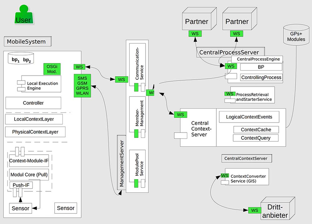
SatNaviServ project: Technical infrastructure for the automated use of mobile devices in business processes based on satellite navigation and web services
Sub-project: Web services for location- and context-dependent business processes (SatNaviServ-FHDW)
This project was the first to discuss the question of how mobile and thus context-dependent systems such as cell phones, PDAs, but also agricultural or construction machinery can be integrated into business processes in a largely automated manner. The concept of the “context” of a system quickly took on a special role, as mobile devices cannot or should not always support all possible processes in a meaningful way. Depending on the situation (context) of the device, only certain processes are possible or permitted. Within the context, the location plays a special role.
In the project, particular attention was paid to making location information available. Satellite navigation provides a natural basis for this, as receivers (especially GPS) are available in the vast majority of mobile systems. However, recording the absolute position is not enough to be able to draw really appropriate conclusions. The location must also be understood semantically so that, for example, the proximity to a place of interest or a place of work can be inferred from the location coordinates. To do this, the location information must be interpreted using a form of expert knowledge. Map providers such as OpenStreetMaps (OSM) and rule systems are suitable for this.
The SatNaviServ project developed a software platform to formally describe business processes, record location information – including via Galileo – recognize its semantics and draw conclusions about possible business processes. This laid the foundations for integrating mobile systems into these processes, which were used in other projects.
Practical relevance and areas of application
If companies want to evaluate or develop the current field of location-based services, the CoSNS work provides a good basis. The concepts and technical blueprints developed there can be used to quickly develop architectures for modern mobile systems that use location information in particular to offer more than just simple customized display functions. Companies can thus benefit from the know-how developed
- want to develop or optimize mobile applications
- want to use and interpret location information
- want to better support business processes with mobile IT systems in particular
- want to use semantic technologies
- want to implement complex control systems technically
- must realize complex combinations of mobile and distributed system components.
Publications
German patent 10 2009 013 213.9-55, granted on 22.06.2011
Method and device for context-driven integration of context-variable systems in process sequences
Based on PCT application PCT/EP2010/053350, European patent application 10715514.5 and US patent application 13/257, 2010