Forschung | it’s OWL-TT-EPlamoH
it’s OWL-TT-EPlamoH
- it's OWL-TT-EPlamoH
- 01.01.2017 - 30.09.2017
- Federal Ministry of Education and Research
- Leading-edge cluster it's OWL - Intelligent Technical Systems OstWestfalenLippe, transfer project
- 42,000 euros
- Prof. Dr. Wilhelm Nüßer
- Sebastian Scholz
- topocare GmbH, Stadtentwässerungsbetriebe Köln, AöR
Improve plans for flood protection measures and use of resources
it’s OWL-EPlamoH project: Optimizing decisions with innovative software
Another research project dealing with flood protection is the EPlamoH transfer project of the it’s OWL technology network. While the TAMMOS project dealt with the operational level, EPlamoH aims to provide efficient support for decisions and measures that have been taken well in advance. This project addresses a question that plays a particular role for local authorities: How can flood protection be designed more efficiently while maintaining at least the same level of safety for people and infrastructure?
To effectively protect their residents against flooding, local authorities have to use a variety of devices. These range from sandbags and hoses to stationary stop log systems. In order to test their functionality, cost-intensive test runs often have to be carried out. The processing of this information and the data from real hazard situations is currently largely manual and not technically supported. Optimized processes can reduce costs while maintaining the same level of safety.
The aim of the EPlamoH project is the prototypical design of a decision support system (EUS) for the flood protection of municipalities. This system should be able to optimize plans for protection measures and the use of resources (people, trucks).
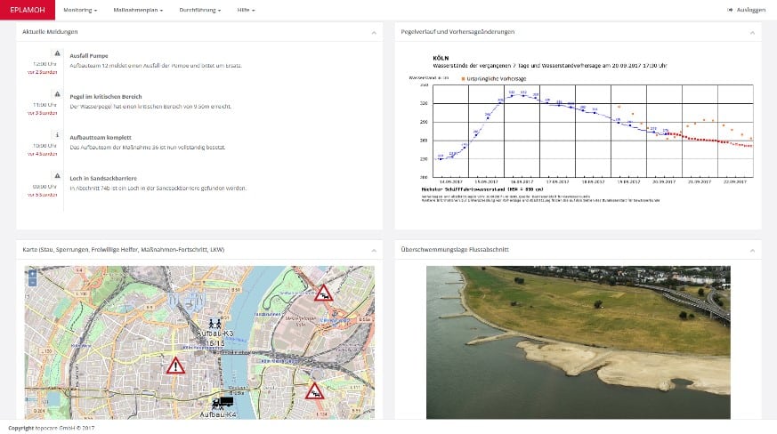
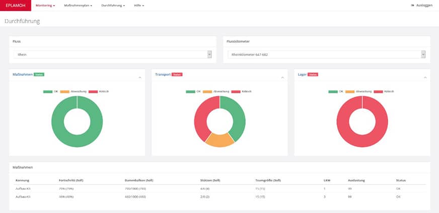
All relevant data at a glance
The components and functions of such an EUS were first specified in the project. Building on this, a demonstrator was developed that integrates and visualizes data as an example. As part of the final sub-goal of the project, the knowledge gained was bundled and a roadmap for a professional monitoring and decision support system was created. The EUS is basically able to display the existing condition of the safety devices, process status data, plan measures and carry out simulations for optimization. Examples of relevant data from the system are the condition of dykes, the development of water levels, images of current flooding situations obtained by drones, the condition of the storage facilities for embankment beam systems, the height of the structure reached, etc. A web-based interface provides a very good platform for displaying and visualizing these data types and selection.